Br
Menu
English
Arabic
Brazil
French
German
Italian
Russian
Simplified China
Traditional China
Spanish
Turkey
India
Vietnam
Japanese
Korean
sobre o app
Contatos
Br
English
Arabic
Brazil
French
German
Italian
Russian
Simplified China
Traditional China
Spanish
Turkey
India
Vietnam
Japanese
Korean
This section is not available yet
Início
Mapas
South Korea
Yonghyeon-dong
Divisões
Melhores locais
Entretenimento
Parque
Sauna
Atrações
Igreja
Negócios
Hospedagem
Comércio
Supermercado
Saúde
Dentista
Hospital
Alimentação
Café
Fast-food
Restaurante
Educação
Jardim de infância
Escola
Universidade
Transporte
Estação de trem
Finanças
Café
이디야
1,0
coffee shop
BOnePC방
1,0
Dentista
Hwang Dental Clinic
2,5
Gimseongsu Dental Clinic
1,5
Escola
솔뫼중학교
Uijeongbu-si, Gyeonggi-do, South Korea, GPS: 37.730675,127.08261
Solmoe Middle School
2,0
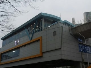
Estação de trem
Tapseok Stn. (탑석역)
충의로 20 (의정부경전철), 용현동, Uijeongbu-si, Gyeonggi-do, 11793, South Korea, GPS: 37.733135,127.08896
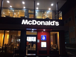
Fast-food
McDonald's
3,5
burger $
South Korea, GPS: 37.730694,127.08642
Price
+
more
Hospital
Seungsoagwa Clinic
2,0
Bonitayoyang Hospital
2,5
Igreja
용현동 성당
용민로21번길 23(용현동 268-33), Uijeongbu-si, Gyeonggi-do, 11785, South Korea, GPS: 37.735695,127.08161
의정부교회
1,0
Jardim de infância
Yuji Kindergarten
1,0
Samseong Kindergarten
2,5
Parque
현대1차아파트 놀이터
2,5
그랜드아파트놀이터
2,5
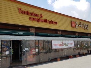
Restaurante
돈까스클럽 용현점
$
South Korea, GPS: 37.73149,127.08303
Price
Reservations
Credit Cards
+
more
BBQ
0,5
chicken
Sauna
Cheonjiyeonboseok Sauna
1,0
Supermercado
CU편의점
2,0
Emart
2,5
Universidade
Inha University 5th Building
South Korea, GPS: 37.451145,126.652336
법과대학
2,0
Show on map
Show list
MAPS.ME
sempre à mão
Baixe o app e comece a expandir seus horizontes
Abrir app MAPS.ME
Usar versão web