Br
Menu
English
Arabic
Brazil
French
German
Italian
Russian
Simplified China
Traditional China
Spanish
Turkey
India
Vietnam
Japanese
Korean
sobre o app
Contatos
Br
English
Arabic
Brazil
French
German
Italian
Russian
Simplified China
Traditional China
Spanish
Turkey
India
Vietnam
Japanese
Korean
This section is not available yet
Início
Mapas
South Korea
Goejeon-dong
Divisões
Melhores locais
Entretenimento
Parque
Atrações
Igreja
Negócios
Hospedagem
Comércio
Supermercado
Saúde
Dentista
Hospital
Veterinário
Alimentação
Educação
Jardim de infância
Escola
Transporte
Posto de gasolina
Estação de trem
Finanças
Banco
Banco
Woori Bank
2,0
Banyawol Nonghyup
2,0
Dentista
Songjaehakuimi Dental Clinic
1,0
에스치과의원 (S Dental Clinic)
1,0
Escola
Daegusongjeong Elementary School
2,5
Estação de trem
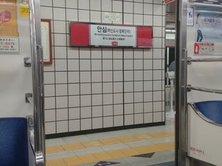
안심역
안심로 지하 455 (대구1호선), Tonggu, Daegu, 41077, South Korea, GPS: 35.87154,128.73448
Ansim Station
1,0
Hospital
Aisarang Oriental Medicine Clinic
0,5
Betelsimnieoneochiryogyoyukwon
1,5
Igreja
호산나교회 (Hosanna Church)
2,5
안심교회
1,5
Jardim de infância
영남유치원
South Korea, GPS: 35.873028,128.7305
Parque
신서공원
2,0
강동 어린이 공원
1,0
Posto de gasolina
Daesin Gas Station
2,0
Ansim Gas Station
1,5
Supermercado
Donghopawo Mart
2,5
e-mart (이마트)
3,0
동구 안심로 389-2 (반야월점), 신서동, Daegu, Daegu, 41084, South Korea, GPS: 35.869904,128.727
Credit Cards
+
more
Veterinário
Kulpet Animal Hospital
2,5
Show on map
Show list
MAPS.ME
sempre à mão
Baixe o app e comece a expandir seus horizontes
Abrir app MAPS.ME
Usar versão web